A gazetteer is any MapInfo table with a field that can be used to identify and navigate to a known location. Gazetteers are created and maintained by the System Administrator. There is a known issue with the MapInfo gazetteer performing very slowly for certain clients on SQL layers, please see the configuration guide for further information on this.
Click on the  button to search the gazetteers. A dialog box will open listing all available gazetteers.
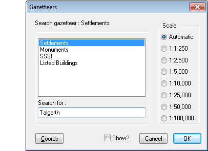
Select the name of the gazetteer you wish to search by clicking on it in the list.
| Field/Button |
Description/Function |
| Search for: |
Enter the name you wish to locate in the ‘Search for’ text box. The above example is searching for “Talgarth” in the Settlements gazetteer. If an exact match is found the site will immediately be displayed in the MapLink Map Window. If, however, an exact match cannot be made a Find dialogue will be shown providing a list of the possible matches in alphabetical order (see below). The closest match to the search entered will be highlighted. Use Up and Down to move though the list, select the item you want by clicking on it and press ‘OK’ to move to the selected site. |
| Scale |
The scale at which to display the site in the Map Window can be set by selecting a pre-set or the automatic scale option. Not all of the pre-set scales would be appropriate for every data set, so users should be aware of the data-sets scales and coverage.
If the automatic scaling option is selected (default) the gazetteer will size the mapper area to fit the specified search object. The exception is if the search object is a point. In this case the maximum zoom level will be used (since a point does not have size). If a value has been entered in 'Size Field' for the chosen gazetteer, then the scale will be set by the value held in the text database record associated with the search value |
| Coords |
Pressing the Coords button displays the Geographic Coordinates dialogue box (see below). It allows a user to navigate to a known location in the Map Window by entering a 2, 4, 6, 8 or 10 digit grid reference or by eastings and northings.
If you search using Geographic Coordinates select a scale first. |
| Grid reference |
An O.S. National Grid Reference is in the form of the sheet prefix followed by at least two numbers, e.g. SN22 or SO222224. You will be warned if the value entered is invalid. |
| Eastings and Northings |
If you know the complete eastings (x-coordinate) and northings (y-coordinate) values for the location you wish to find, they may be entered in these two boxes. The values must be entered in metres. |
| Address |
This button is visible if the exeGesIS SDM Address Finder software is installed. It runs the Address Finder program. |
| Show? |
If this box is checked and the layer that is being searched is not displayed in the current map window, then the layer is added to the map. |
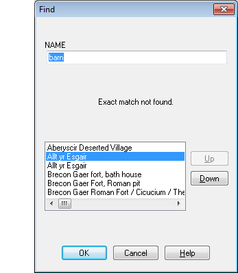
Multiple matches dialogue
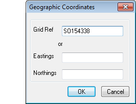
Search by Grid Ref or Coordinates dialogue